Alfred Oteng-Yeboah, University of Ghana
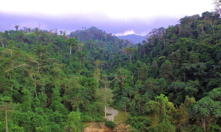
Ghana’s Atewa forest is one of the most beautiful and scenic landscapes in the country. It is seen as the better of only two Upland Evergreen forests left intact in the country, forming part of the six dominant vegetation zones of Ghana based on different climates zones.
The Atewa forest is part of the Guinean Forests of West Africa which stretch from southern Guinea into eastern Sierra Leone and through Liberia, Côte d’Ivoire and Ghana into western Togo. Deforestation has massively reduced the size of the forests and the Upper Guinea Forest is now restricted to a number of more or less disconnected reserves and a few national parks acting as man-made refuges for the region’s biodiversity.
The Atewa forest landscape is remote and pristine, providing the habitat for a major collection of Ghana’s biodiversity. It has been named as one of Ghana’s 30 globally significant biodiversity areas.
But the forest is under threat. Last year Ghana signed a memorandum with China to explore Ghana’s deposits of bauxite – the primary ore in aluminium. The deposits are found in two locations – Awaso with very high deposits in the moist semi-deciduous forest zone of western region of Ghana, and Atewa, with minimum deposits and located in the Upland Evergreen forests in the Eastern Region of Ghana.
Under the memorandum Ghana will cede 5% of its bauxite resources to the Chinese. In turn, Beijing will finance $2billion worth of infrastructure projects that include rails, roads and bridge networks. The Ghanaian Parliament has passed the Ghana Bauxite Integrated Aluminium Industry Act which would provide a legal framework to exploit country’s bauxite deposits.
Yet the government says it still has to validate the true worth of the bauxite deposit in the forest.
As a botanist I view the Atewa landscape as a scientific gold mine. A recent impact assessment by the US Forest Service corroborates the concerns of several conservation groups about the potential damage that mining would cause.
I believe strongly that Atewa is not for mining and that it must be preserved. Firstly, it needs to be preserved as a living natural history laboratory. Secondly, it should be protected because it provides a vital resource – water. Thirdly, it is a precious gift whose value cannot be quantified, but which must be lived, felt and appreciated. Finally it is a naturally bequeathed heritage that must be protected for future generations to enjoy.
The forest
An interesting characteristic of the Atewa forest is that the canopies of its trees are not easily visible as they merge with the surrounding clouds creating a beautiful cloud cover line. This is very rare in the Ghanaian landscape. This feature is described in local parlance as the phenomenon in which the trees are in direct communication with the firmament of the heavens and bring good tidings to the ground underneath.
Scientifically, the phenomenon is responsible for the daily condensation of water vapour which falls as precipitation. As a result the mountain top is kept permanently moist. This in turn explains the interesting hydrological networks beneath the soil surface. The water percolates down to create under ground water ways as well as water falls and many streams and tributaries that coalesce or combine to form Ghana’s famous three rivers. These are the Ayensu, Birim and Densu.
The three eventually drain their basins as they meander through the forests and farm fields providing essential water resources to over 5 million inhabitants. They also deposit suspended clay and silt materials as fertile alluvial for crop production during the rainy periods when they burst their banks and overflow.
The Atewa landscape provides rich forest cover for climate regulation, a show piece to illustrate climate adaptation to avoid drought, reduce poverty and enhance sustainable livelihoods and improve human well being in its catchment area.
The landscape has been the subject of research by geologists, hydrologists and geo-morphologists. A geologist studies studies the solid, liquid, and gaseous matter that constitute the Earth while a geo-morphologist studies the earth’s surface. A hydrologist is a scientist who researches the distribution, circulation, and physical properties of the earth’s underground and surface waters.
Studies of the fauna and flora of the area have brought up new scientific discoveries of species like the critically endangered white-naped mangabey Cercocebus lunulatus. This shows that the knowledge of the faunal and floristic diversity and to a large extent the microbial diversity is still at the exploratory stages.
I would strongly argue that the Atewa landscape is an important species discovery destination, awaiting extensive research and studies. It should, therefore, not be disrupted or destroyed by mining.
Alfred Oteng-Yeboah, Associate Professor of Botany, University of Ghana
This article is republished from The Conversation under a Creative Commons license. Read the original article.
